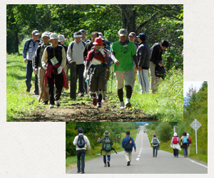
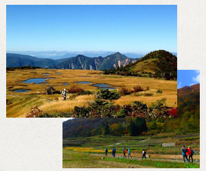
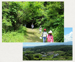
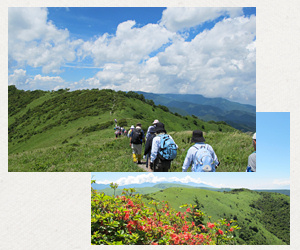
Å@Å@ Large Photos Tokachi, called "Breadbasket of Japan", produces grains, beans, vegetables, dairy, meat and seafood, which is shipped all over Japan.This trail invites you to witness the bounty from the rich farmlands surrounded by beautiful mountains, hills and the ocean of southeast Hokkaido.
Rambling at Tokachi Long Trail definitely appeals to the senses: you can see the spectacular Central Ishikari Mountains including the active volcano Tokachi, the Hidaka Mountains, a terrain inaccessible to humans and an endless star filled sky during the night.You can hear the high-pitched whistle of a Japanese pika (Ochotona hyperborea yesoensis), the knocking sound of a Black woodpecker (Dryocopus martius) as well as smell the ancient Yezo spruce (Picea jezoensis) and Erman's birch (Betula ermanii) of the forest around Lake Shikaribetsu. This lake is especially interesting because the Hokkaido aboriginal Ainu, used to worship this lake as a mystic place.
You will of course be able to savor the taste of fresh authentic local cuisine like Soba (buckwheat) noodles and Butadon (bowl of teriyaki flavor pork on rice) and to feel calm in high quality hot springs with the incredible healing energy of Tokachi.
Å@Å@ Large Photos
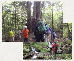
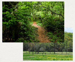
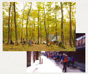
The Aomori Hiba tree (Thujopsis dolabrata var. hondae) is deemed to create one of the most beautiful forests in Japan and Okutsugaru constitutes a major forestry region in Tohoku area.
This endemic species takes 200 years to mature and its unique constitution makes it possible to survive through the rough winter in Aomori. Eighty percent of Hiba wood comes from here. It has a great reputation for preservation quality because it contains high levels of Hinokitiol, an antiseptic essence of the conifer. This has been protected strongly as major local resource for a long time.
From 1906 to 1967, when the demand for wood in modernized cities was rapidly increasing, logging railways ran all over the Tsugaru peninsula. In fact, the total length of the railway track, 121km, means it was the longest logging railways in Japan. Recently, the old railway tracks have been reopened as a new trail for hiking, called the Okutsugaru trail.
There are eight different routes you can choose depending on your ability level. You will discover about the botany of Hiba, timber industry heritage, local folk culture including Tsugaru shamisen (Japanese three-stringed musical instrument) and Goshogawara-Nebuta (parade of enormous lanterns for summer festival).
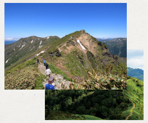
Å@Å@ Large Photos Shin-etsu Trail runs along forested mountain ridges on the border between Nagano and Niigata prefectures in the center of Japan. It passes through the points of 16 ancient crossroads while connecting the mountainous inland areas to the ocean for food transportation as well as, travelers and warriors. Because of this, it has grown into an historical and cultural exchange area. Several mountain villages near the trail still retain the atmosphere of the olden days.
The area is also known for heavy snowfall and can get up to eight meters, which though tricky for humans, limits access and protects wildlife. The walking trail has different expressions from season to season: in spring native swallowtail butterflies, Gifu butterfly (Luehdorfia japonica) and Himegifu butterfly (Luehdorfia puziloi) come to wild flowers bursting into bloom. Forest Green Tree Frog (Rhacophorus arboreus) sponge-like egg masses are suspended from tree branches over a pond. Cute looking Japanese Black Salamanders (Hynobius nigrescens) come to a pond to release eggs in the water. In summer the Japanese Beech trees (Fagus crenata) provide fresh cool air as relief from heat; in autumn, mountains covered by splendid color of leaves and in winter, a wilderness of white dominated landscape. For a change from walking, you can enjoy canoeing in summer and skiing in winter too.
Å@Å@ Large Photos Satoyama is the Japanese term for a landscape where traditional farming land of the plains meets mountains; a place where people have lived in harmony and peaceful coexistence with the natural environment since ancient times. Bamboos, Japanese beeches and Sawtooth oak woodlands surround the traditional farm houses, and brooks of pure water run through rice fields and orchard. These all combine to create a high level of biodiversity.
Many famous Japanese poets have been inspired in their work by the Satoyama in this area. They have great symbolic importance and represent a nostalgic perspective that makes you feel truly welcome and at home.
Asama Yatsugatake Panorama Trail in Nagano guides you into the "heart of Japan" where you can have an authentic Satoyama experience with a wonderful panoramic view of major mountains, Mt. Asama, the Yatsugatake mountains, the Northern Japan Alps, Mt. Fuji and the longest and largest river, the Chikuma river (called the Shinano river in Niigata). In addition, this area used to flourish as an outpost on old major highways. Komoro village on the Hokkokukaido historic highway and Mochizuki village on the Nakasendo historic highway used to serve travelers walking the highways from Tokyo to Niigata and Tokyo to Kyoto respectively. You can still see some traces of the past along this trail walk.
Å@Å@ Large Photos
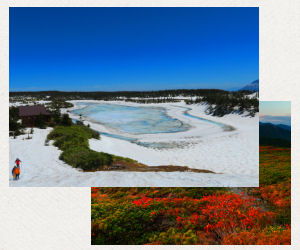
Yatsugatake, two volcanic groups in the mountain range in central Japan are a mecca for outdoor lovers and artists who enjoy the ceaseless beauty of nature.They are easy to access from major cities. Walking on Yatsugatake Sanroku Super Trail can feel like going back in time and allows you to take in the natural and human history all year around. The trail progresses at an average height of around 1500m to the high point of the mountain range with the best panoramic view of the Japan Alps and Mt. Fuji.
Eight meter deep peat layers formed over the past 12,000 years have created a high moor at the southern edge of Japan. Known as the Yashimagahara moorland which has over 400 varieties of alpine flowers. This bountiful natural environment attracted Neolithic Jomon civilization whose cultural traces are well illustrated by the famous ancient clay Jomon Venus sculpture discovered in the area. Also small stone shrines and Buddha statues along the path hint at other deep mountain worshippers from ancient times. You can feel people's passion by passing through Shingen-boumichi, a military road created in the sixteenth century by a local powerful feudal lord Shingen Takeda. This is also where the most dangerous festival Onbashira began which sees men ride down a hill sliding on huge logs.
Å@Å@ Large Photos
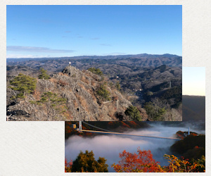
In ancient times, salt was one of the essential products and many trade routes going from the seaside inland had developed in Japan, called "Shio-no-michi". Because 72 percent of Japan's land is mountainous, transporting salt was a tough, sometimes life-risking business, especially in a severe winter. Shio-no-michi Trail (Shio-no-michi means salt road in Japanese) reconditioned the oldest salt road - Chikuni Kaido - between Niigata and Nagano, so now walkers can re-live the experience of carrying salt alongside the fascinating local culture and heritage related with the trade. The key point of the trail is walking parallel to the Northern Japan Alps and seeing the dynamic range from end to end. It starts from the coastal town Itoigawa, in Niigata, where the mountains of the Northern Japan Alps meet the Sea of Japan. The area is well-known for its distinctive geological and topographical characteristics, and the world's oldest known jadeite-using culture. It has been listed as UNESCO Global Geopark. After walking through old villages, onsen hot spring spas, soba noodle shops and wasabi farms at the bottom of the splendid Alps, the trail finishes at Matsumoto, Nagano, which is renowned as one of Japan's most beautiful original condition castles.
Å@Å@ Large Photos Kirigamine Utsukushigahara Chuuou Bunnsuirei Trail progresses along the ridge between the Mt. Kirigamine and the Utsukushigahara lava plateaus in Nagano. This ridge, standing at the very center of Japan is the watershed dividing line between the Sea of Japan and the Pacific. The trail is also near the Chubu Node which is the crossing point of the Median and Itoigawa-Shizuoka tectonic lines. It is part of a major volcanic chain creating a wide range of stunning landscapes and high quality mines including obsidian.
The use of obsidian has been in place since the Neolithic period which is in part why this area was able to prosper by trading and establishing distribution channels. The highest and toughest pass at the old Nakasendo highway, Wada pass, marks where all classes of people, including the Imperial family members traveled. To taste the historical atmosphere there are detour paths visiting those heritage sites and easy access to roads enables further detours to the Suwa Grand Shrine and the premier historic landmark, the Matsumoto castle. At Utsukushigahara enjoying a hot spring is the best way to experience "the life of the earth" while also being at the mid-spine of Japan surrounded by high peak mountains.
Å@Å@ Large Photos Kanazawa Trail is a showcase of Japan's traditional culture - a samurai castle town, Japanese gardens, arts and crafts, food markets, traditional country life, mountain worship, and hot springs - perfect for soaking in a real taste of Japan. Kanazawa, the biggest city in the Hokuriku region, the northwestern part of the Sea of Japan, had been governed by the second powerful feudal clan, the Maeda, and used to be the fourth most prosperous city in Japan during Edo period (1603 - 1868).
Start walking from the center of the city though the old samurai, geisha and temple districts, which managed to escape destruction by air raids during WWII and today remain in their original condition. Once the trail changes to gentle hillwalking, leading toward one of the major mountains worshipped in Japan, Mt. Haku, a state of profound peace and stillness surrounds you. Small shrines, front guard frames, and statues of Jizo (Kshitigarbha) are dotted beside the trail, which tell the stories of the many monks who practiced asceticism, and consecrated themselves as they walked in this hallowed area. There is also a hidden hot spring resort of the Maeda, Yuwaku onsen, for further peace of mind.
Å@Å@ Large Photos
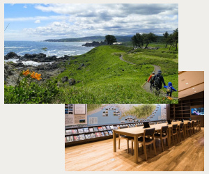
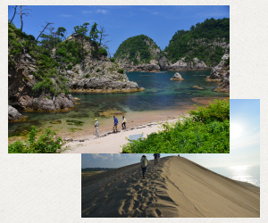
There is a stunning UNESCO Geopark coastline at Sanin, in the southwest of the Japanese main island. Visiting the San'in Kaigan Geopark Trail in Tottori is like visiting an outdoor museum of rare natural heritage. Here you can learn about the process of how Japan went from being part of the Asian continent, to its present-day formation, and how wildlife and humans have coexisted in harmony with its geodiversity.
There are a variety of fascinating geological features, such as dynamic natural art works of tunnels and caves made by the encroaching waves and winter winds, superb natural bonsai arts of pine trees, rapeseed flowers growing on top of abrasion rocks in the water, sparkling white quartz sand beaches along transparent cyan sea, and ever-changing sand dunes that are covered in beautiful patterns made from the winds. Boating, sea kayaking, diving and paragliding are other excellent options that allow you to enjoy this unique scenery.
In charming fishing villages by the ria coast, houses are perched on slopes stand closely together and create a relaxed atmosphere in the maze-like alleys. The harbors are covered in Japanese flying squids and fish that land on the coast, and which are sun-dried during summer. In winter, all tough fishermen sail out into the to severe cold and rough seas to catch snow crabs, which are the most expensive and exquisite seafood in Japan.
Å@Å@ Large Photos
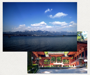
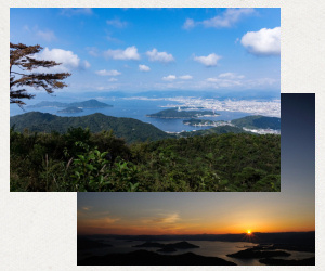
The topography in and around Hiroshima is a microcosm of the wider Japanese natural landscape, making it a unique place. The city stands on five deltas with six rivers flowing between them. The rivers' water originally comes from the lush green mountains behind the deltas, and flows into the deep blue Seto Inland Sea dotted with almost 3000 islands. This majestic scenery that created Hiroshima is well-known due to two icons - a floating red Torii gate on the water, Itsukushima Shrine and the A-Bomb Dome of the Hiroshima Peace Memorial. Both are listed as UNESCO World Heritage Sites and are some of the top foreign tourist destinations today.
Hiroshima Wangan Trail can offer a way to step deeper into local life, allowing visitors to
understand how much this delta city has effected Japanese history, industry and culture. It
has specially designed walking paths 360 degrees around the city. The paths include mountain hiking, crossing the sea, and passing by three prominent features, the two World Heritage sites and one Japan Heritage site - Kure port which has been developed as a naval port, helping to push forward Japan's modernization.
If you fancy grabbing a bite to eat, try the local street food: Hiroshimayaki (Hiroshima style Okonomiyaki - a savoury pancake), oysters and a steamed bun, Momiji manju. TheyÅfll all
give you plenty of energy for your walking trip. In addition, Hiroshima is one of Japan's
three great sake-producing areas so it's a perfect spot for sake tasting.
Looking at the city from the picturesque view of the mountains or the sea and thinking about the world peace would be unforgeable experience for you.
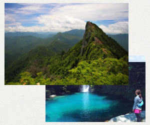
Ishizuchi Mountain Range Long Trail
Åitotal 60kmÅj
Å@Å@ Large Photos
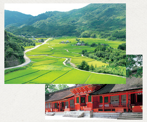
One of the most distinctive characteristics of Japanese culture is the ability to absorb new things from outer regions of the country that merge with their traditions, creating a unique local style. Even religion is not an exception. Rokugo Manzan is a syncretic religion created from a mix of Buddhism (originally from India, introduced by China), Shinto (Japanese originally) and mountain worship practices (local originally) had coalesced in the Kunisaki peninsula, Oita prefecture in seventh century, which has been passed along and survives to this day.
Radiating out from Mt. Futago at the center of the peninsula are 65 temples, thousands of stone Buddha statues and reliefs that were set up in the six districts along the valleys. Kunisaki Hantou Minemichi Long Trail is based on the footsteps of the monks who practiced the asceticism of Rokugo Manzan. It is a heavenly experience to immerse yourself in the essence of the Japanese spirit and philosophies by exploring the unspoiled holy spots, the pastoral villages next to 1000 year-old rice paddy terraces and sawtooth oak forests that produce top-quality Shiitake mushrooms.
For a more serene atmosphere, there is an opportunity for visitors to try Zen meditation and sutra transcribing at some of the temples or to stay in the homes with the local farmers.


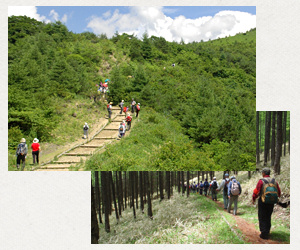
 Tokachi Long Trail

 Official site